Provence · France

Mont Ventoux & Vaucluse

Mountain views, foothill villages & the lavender country around Sault

Plan around the mountain, then give its surrounding villages and landscapes room to unfold. Bédoin, Malaucène and Sault are different starting points; a summit outing, a market morning and a scenic gorge route each deserve their own pace.

Plan My Trip
Lavender country around Sault with Mont Ventoux in the distance

Mont Ventoux & Vaucluse at a Glance

This guide focuses on Mont Ventoux, Bédoin, Malaucène, Le Barroux, the Sault plateau and the nearby Gorges de la Nesque. “Vaucluse” describes this selected area around the mountain; it does not mean a tour of the entire department. The Luberon and Avignon remain separate destination guides.

Destination

Mountain & surrounding villagesThree principal approaches: Bédoin, Malaucène and Sault.

Time to allow

2–3 days for a varied stayA single day should focus on one side of the mountain.

Main interests

Scenery, markets & outdoor timeVillage life, lavender country, cycling and chosen walks.

Best rhythm

Weather first, villages secondKeep the summit flexible and allow a lower-altitude alternative.

Getting around

Car or planned driverPublic transport can reach some villages; onward travel matters.

Physical effort

Choose your level carefullyA scenic drive, a lavender loop and a summit hike are different outings.

Visit lengths, suggested combinations and travel styles are FWP editorial advice. Practical sources checked 2026-10-01.

Why Visit Mont Ventoux & Vaucluse?

Ventoux gives northern Provence a strong sense of scale. The landscape changes between vineyards, wooded slopes, cultivated plateaux and the exposed upper mountain. You can enjoy that contrast without attempting a sporting ascent: choose the right approach, pause in a village and leave time to see the countryside between stops.

The best stay usually balances a mountain day with something more grounded. Monday in Bédoin, Wednesday in Sault or Malaucène, a château visit at Le Barroux or a carefully planned drive through the Nesque can each provide that contrast. Lavender is a seasonal bonus, not the only reason to visit.

Where to Go & What to See

Choose a western foothill cluster around Bédoin, Malaucène and Le Barroux, or an eastern cluster around Sault and Monieux. The summit is a separate weather-dependent outing. FWP visit lengths below exclude substantial drives, parking and meals.

The mountain · weather-dependent

Mont Ventoux summit area

When the road and conditions allow, approach the upper mountain for its broad views and distinctive limestone landscape. Use designated parking and the signed visitor route, with time to adjust to the wind and temperature.

Allow: 45–90 minutes at the upper visitor area, plus the full ascent and descent
Best for: Wide landscapes and travellers wanting a road-based mountain experience

Plan for: Road openings are seasonal and approach-specific. Strong wind, poor visibility, fire restrictions or an event can change access. A scenic road visit is not a substitute for preparation on a hiking or cycling ascent.

Official visitor information ↗

Southern foothills · a village base

Bédoin

Walk the village streets and use its cafés, market and visitor information as a gentle introduction to the southern side of Ventoux. The older quarter rises towards the church above the main village.

Allow: 1–1½ hours; longer on market Monday
Best for: Village atmosphere, food and a southern mountain base

Plan for: The upper village involves slopes. Monday’s market changes traffic and parking; park legally outside the stall area and continue on foot.

Official visitor information ↗

North-western approach · a separate village

Malaucène

Explore the historic centre and its architectural details, with a break before an onward mountain or countryside outing. The Wednesday market is a useful reason to start the day here.

Allow: 1–1½ hours
Best for: Village walks, market mornings and the northern approach

Plan for: The road through Mont Serein has a different seasonal opening from the Chalet Reynard side. Do not assume that reaching Malaucène means the summit road is open.

Official visitor information ↗
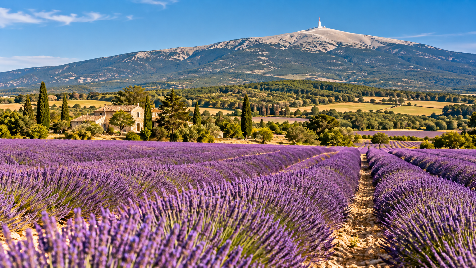
Lavender fields in the Sault area below Mont Ventoux

Eastern Ventoux · agricultural landscapes

Sault & the surrounding plateau

Give Sault time as a village before exploring its surrounding lavender and grain country. Wednesday’s market, local food shops and a modest countryside outing make a coherent day on this side of the mountain.

Allow: 1–2 hours in town, plus the chosen countryside visit
Best for: Rural landscapes, local produce and a quieter base

Plan for: Flowering and harvest vary by field, altitude and year. July is the main planning reference in local visitor information, not a guarantee that every field will be purple.

Official visitor information ↗

Sault · an interpretation walk

Chemin des Lavandes

Follow the signed loop through the agricultural landscape to learn about lavender cultivation and processing. The official description gives a 5.3 km circuit; it remains a landscape walk outside flowering time.

Allow: 1½–2 hours at a leisurely pace
Best for: A relatively gentle countryside walk and an introduction to lavender

Plan for: “Very easy” in the tourism grading does not mean fully step-free. Use the current route map, carry water, stay on paths and respect working fields. Flowering is usually July to early August, subject to harvest.

Official visitor information ↗
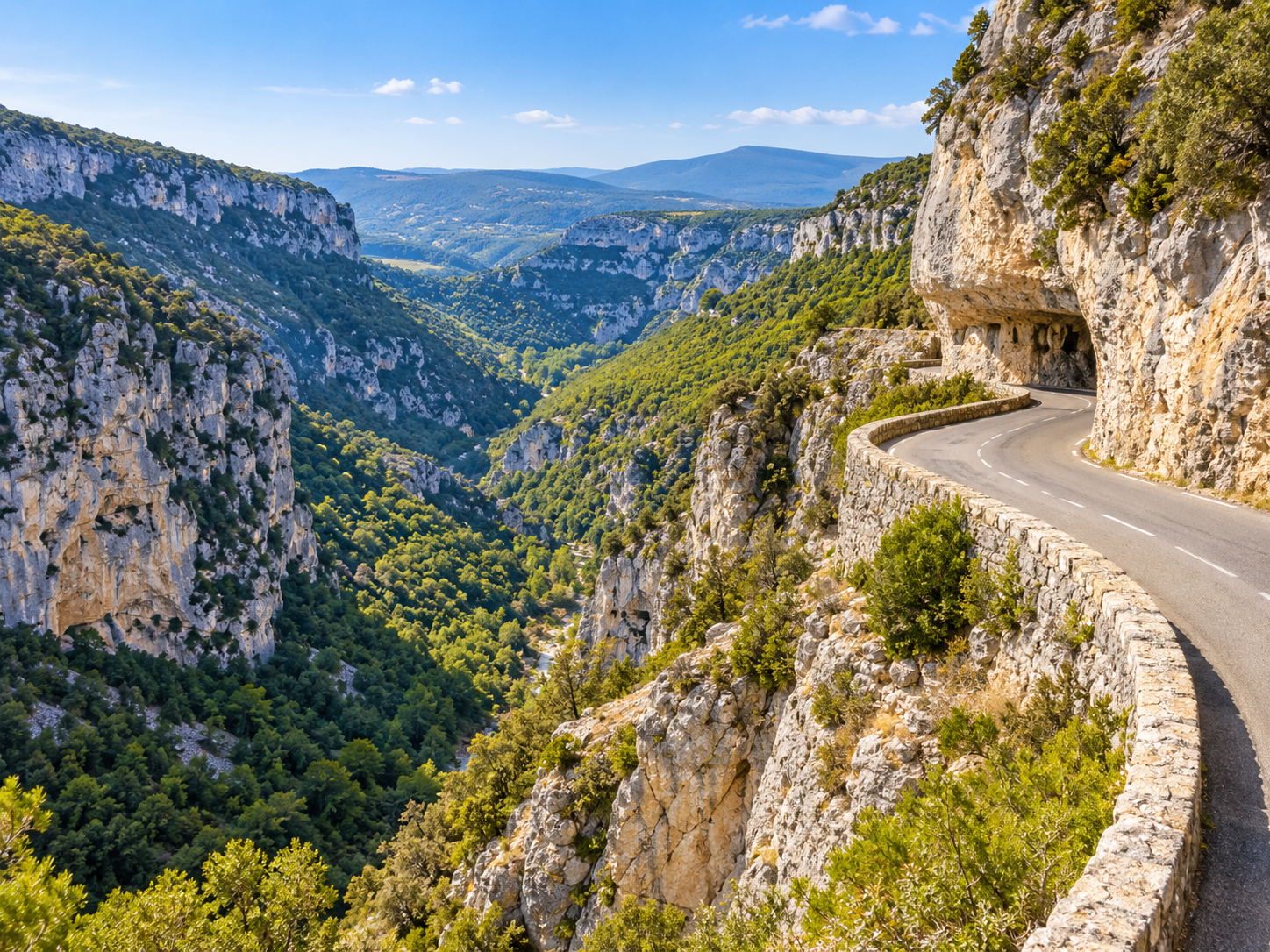
The Gorges de la Nesque road winding through limestone scenery

Eastern foothills · a scenic route

Gorges de la Nesque & Monieux

Explore the gorge landscape from the D942’s designated stopping places, pairing the outing with Monieux or Sault. A road-and-viewpoint visit is a different undertaking from a descent on foot into the gorge.

Allow: 2–3 hours for a scenic outing with stops; more for a hike
Best for: Limestone scenery, photography and an unhurried road trip

Plan for: The route has bends, tunnels and cyclists. Check current restrictions and vehicle suitability; event closures can reserve it for non-motorised use. Do not stop in a tunnel or treat a roadside verge as a viewpoint.

Official visitor information ↗

Western foothills · heritage and views

Le Barroux & its château

Pair the village with a self-guided château visit through rooms, courtyards and terraces. The distillery is a separate guided experience, so choose the visit format before arranging your day.

Allow: 1½–2½ hours for village and château
Best for: Heritage, families interested in history and a village lunch

Plan for: The château’s rooms are separated by steps. Independent wheelchair access is not possible throughout; contact the team to discuss a tailored visit and the designated accessible parking space.

Official visitor information ↗

What to Experience

Scenic outing · conditions apply

See the mountain by road

Choose one approach based on your starting point and the day’s official road status. Add generous time for cyclists, lawful viewpoint stops, parking and the descent. Keep a village-only alternative. Current summit access ↗

Free walking routes

Walk at a suitable level

The Chemin des Lavandes offers a modest introduction to the Sault landscape. High ridges and summit trails require a separate route assessment, equipment and weather check; choose a qualified guide when needed.

Sporting day · services may be paid

Make cycling the main activity

A Ventoux ascent is a substantial sporting objective. Match the route, bicycle, support and descent plan to your experience. Rental or guided support should be reserved in advance, with weather and road closures checked again.

Paid visits · guided slots to confirm

Discover the château and distillery

Choose the self-guided heritage visit or the guided distillery format at Le Barroux. The operator presents whisky made with local small spelt; confirm the programme and tasting arrangements for your date. Visit formats ↗

Free to browse

Follow a market morning

Choose Bédoin on Monday or Sault or Malaucène on Wednesday. Add one nearby visit and lunch rather than crossing the mountain to collect several markets.

Seasonal landscape · visits vary

Look for lavender thoughtfully

Use flowering reports and the local route information close to the trip. Photograph from permitted paths, avoid trampling crops and leave access clear for agricultural vehicles. A distillery visit can add context when fields are already cut.

Markets Worth Planning Around

Town & marketWhenPlanning notes & source
Bédoin · Provençal market
Village centre
Monday
8 am–1 pm
Year-round in the published listing
Leave time for traffic and pedestrian access. Follow the day’s parking signs outside the market streets; add the upper-village walk only if its slopes suit your group.
Official market details ↗
Malaucène · weekly market
Cours des Isnards
Wednesday
8 am–12:30 pm
Regular weekly market
Choose this market for a western foothill day. Park outside the stall area and check temporary street restrictions; a summit visit remains conditional on road and weather checks.
Official market details ↗
Sault · weekly market
Village squares and streets
Wednesday
8:30 am–12:30 pm
Year-round in the published listing
A useful anchor for the Sault plateau or Monieux. Use signed visitor parking and walk into the market area; allow extra time in lavender season.
Official market details ↗

These are regular markets unless marked seasonal. Dates cover the published calendar; holidays, weather and local events may affect stalls and access. Recheck before travelling.

Where to Eat

Keep the restaurant on the same side of the mountain as the rest of the day. These choices range from a seafood bistro to Provençal cooking and a more refined meal; none requires adding a long summit crossing just for lunch.

Bistro · fish & shellfish

Le Bistrot du Large · Bédoin

At 7 Chemin de Meneque, this restaurant focuses on fish, shellfish and a bistro atmosphere near the Ventoux foothills. It offers a different flavour from a traditional village menu while remaining a Bédoin-area choice.

Reserve: Contact the restaurant using its official site or published telephone; confirm the actual service date and menu.
Official restaurant & reservations ↗

Traditional Provençal cooking

Les Géraniums · Saveurs & Terroirs · Le Barroux

The hotel restaurant on Place de la Croix highlights local, seasonal produce and Provençal cooking. It fits a château-and-village outing; confirm the current menu, as the website’s menu page is being updated.

Reserve: Contact the restaurant directly for a table. The hotel’s room-booking form is not a restaurant reservation.
Official restaurant & reservations ↗

Refined dining · countryside setting

La Colombe · Bédoin

At 3890 Route du Mont Ventoux, Christophe Schuffenecker’s restaurant centres its cooking on local seasonal ingredients and aromatic plants. Plan it as a meal in its own right, with an unhurried return.

Reserve: Use the reservation link on the official site. Check lunch availability: the published pattern differs between weekdays and weekends.
Official restaurant & reservations ↗

Confirm the current menu, service dates, dietary needs and step-free access directly before booking. Selections are based on published information, not a claim of a personal FWP visit or partnership.

When to Visit

March–May

Spring

Lower villages and walking routes make a good starting point. Summit roads reopen by approach and by annual decision; snow or weather can still affect the upper mountain.

June–August

Summer

Plan early outdoor time and a cooler midday break. Sault’s lavender is typically a July focus, sometimes extending into early August before harvest. Check fire access and avoid promising a fixed peak week.

September–February

Autumn & winter

Autumn can suit villages and food-led visits, with weather-dependent mountain outings. Winter summit-road closures change the plan completely; do not treat a summer drive as a year-round route.

The official destination guide describes typical reopening around mid-April on the Chalet Reynard side and mid-May via Mont Serein, with dates confirmed each year. These are seasonal patterns, not a guarantee for a future trip. Check the current access bulletin and sports-event notices before departure. Road status ↗ · Events and temporary closures ↗

How Long to Spend

One coherent side

One day

Pick one cluster: Bédoin with Le Barroux, or Sault with Monieux and a selected scenic route. Add the summit only as the main outing, with suitable conditions and enough return time.

A balanced introduction

Two days

Give one day to the mountain and western foothills, and one to the Sault plateau. Reverse the order to suit weather, opening days and a market morning.

Room for outdoor interests

Three days or more

Add a dedicated cycling or hiking day, a longer meal and time to explore at village pace. The extra day gives useful flexibility if the summit is unsuitable.

FWP planning recommendations. Allow separately for your arrival journey and accommodation transfers.

Getting There

Use Bédoin or Sault as a named arrival when comparing transfers from Avignon TGV or Marseille Provence Airport. They sit on different sides of the area; a generic “Ventoux” transfer does not identify your accommodation, trailhead or summit parking.

Named routeApproximate driveRoute source
Avignon TGV Station → Bédoin village45–60 min · around 45 kmRoad route ↗
Avignon TGV Station → Sault village75–95 min · around 67 kmRoad route ↗
Marseille Provence Airport (MRS) → Bédoin village85–110 min · around 95 kmRoad route ↗
Marseille Provence Airport (MRS) → Sault village100–125 min · around 104 kmRoad route ↗

For a car-free arrival, investigate a rail connection to Carpentras and the date-specific onward bus. Trans’CoVe line L links Carpentras and Bédoin; check the complete outward and return journey. A village bus is not a summit shuttle, and accommodation outside the centre needs its own last-leg plan.

Official line L timetable ↗

A prearranged driver is useful for a scenic day or a one-way outdoor itinerary. Agree the actual meeting point, vehicle access, waiting time and return plan. Road ranges exclude luggage handling, vehicle collection and parking.

Getting Around & Parking

PlaceParking referencePractical use & source
Ventoux · southern upper areaDesignated D974 spaces / Sud “Tempête” parkingUse the signed places when the approach is open. Check live occupancy and the visitor plan; roadside overflow is not a safe fallback. Official summit parking guide ↗
Ventoux · northern upper areaNord “Radôme” parkingThe northern approach has its own seasonal access. Confirm the final walking route and current conditions rather than assuming the car reaches every viewpoint. Access and site plan ↗
Chalet ReynardChalet Reynard parkingA named trail-start parking area in the tourist-office route information. Parking does not make a ridge hike easy or establish that the route is open. Trailhead reference ↗
Sault · lavender loopSigned parking shown on the Chemin des Lavandes mapUse the route’s actual start rather than parking in a field entrance. Check the map before leaving the village. Official route leaflet ↗
Le Barroux châteauAccessible space in the lower courtyardThe operator identifies one PMR space; arrange access directly. It does not remove the steps between the château rooms. Château accessibility ↗

For Bédoin, Malaucène, Sault and Monieux, follow current municipal signs and leave the car before exploring the old streets. Specific village parking tariffs, availability and chauffeur drop-off permissions have not been confirmed. Market mornings and sporting events can alter the usual arrangement.

For the Gorges de la Nesque, check your vehicle’s size against current signs and restrictions before committing to the D942. Use proper stopping places, share the road patiently with cyclists and avoid making a scenic road the only route to a fixed appointment.

Drive Times & Suggested Combinations

These rows describe village-to-village transfers, not summit crossings. The short Bédoin–Malaucène connection does not go over the summit. A full mountain outing needs additional ascent, stop, parking and descent time based on the actual open route.

Named routeApproximate driveRoute source
Bédoin village → Malaucène village15–25 min · around 12 kmRoad route ↗
Bédoin village → Le Barroux village15–25 min · around 12 kmRoad route ↗
Sault village → Monieux village10–20 min · around 6 kmRoad route ↗

For the summit and the Nesque scenic road, use a current route planner after checking closures, then add a generous margin for bends, cyclists and stops. No fixed summit drive time is asserted here: a generic routing result is too easy to mistake for a dependable mountain schedule.

Approximate drive times. Traffic, season and parking can affect your journey. Rounded planning ranges include a modest margin over retrieved road estimates, exclude parking and walking, and are not live navigation predictions.

Western foothills

Half day: Bédoin & Le Barroux

Allow 4–5 hours locally for a village walk, the short transfer and the château, with time for a break. A Monday market or a booked lunch turns this into a longer outing.

Eastern landscapes

Full day: Sault, lavender country & Monieux

Allow 7–8 hours locally, plus arrival travel. Begin with Sault, choose the lavender loop or a shorter landscape stop, have lunch, then continue towards Monieux and selected gorge viewpoints if access permits.

A flexible base

Three-day Ventoux stay

Day 1: Bédoin and Le Barroux. Day 2: a weather-appropriate mountain outing via the confirmed open approach. Day 3: Sault and the Nesque, or a dedicated sporting day. Reorder the mountain day instead of forcing it into poor conditions.

Accessibility & Practical Advice

Place or activitySpecific considerationPractical choice
Ventoux upper visitor areaWind, cold, exposed terrain and the distance from designated parking affect comfort.Check the site plan and current accessible route with the tourist office. A road arrival is not a blanket step-free guarantee. Visitor information ↗
Château du BarrouxRooms are separated by steps; the operator says independent wheelchair circulation is not possible throughout.Call in advance to discuss a tailored visit and the PMR parking space. Operator access details ↗
Bédoin / Malaucène old quartersHistoric streets and upper viewpoints can add slopes and steps.Keep to a compact lower-village route when gradients are a concern.
Chemin des LavandesA tourism grading of very easy does not certify wheelchair or pushchair suitability.Check the map and current surface conditions with the Sault visitor office. Trail information ↗
Nesque viewpointsStopping places and the distance to a view vary along the road.Choose safe designated stops and confirm access individually; do not assume every viewpoint has a level path.

The official destination guide flags large temperature differences between the foot and summit, strong wind and summer fire restrictions. Check the Vaucluse access map linked there before an outdoor outing. Carry suitable layers, water and sun protection, and adjust the route to the least confident person in the group. Weather and fire-access guidance ↗

FWP Insider Advice

  1. Name the side of the mountain.
    Bédoin, Malaucène and Sault are not interchangeable hotel or pickup locations. Check the actual accommodation address before arranging transfers.
  2. Keep the summit optional.
    An enjoyable village and food day is a sound alternative when the upper mountain is windy, closed or clouded over.
  3. Let the market choose the cluster.
    Monday in Bédoin and Wednesday in Sault or Malaucène provide simple anchors. Do not spend the morning driving between markets on opposite sides.
  4. Treat lavender as a working crop.
    Ask about the current flowering and harvest locally, stay on public or permitted paths and avoid blocking agricultural access.
  5. Separate a sporting ascent from a sightseeing circuit.
    A serious ride or hike deserves its own recovery, food and return plan. Do not add a long mountain descent to a tight dining reservation.

Mont Ventoux & Vaucluse FAQ

Does this guide cover all of Vaucluse?

No. It focuses on Mont Ventoux, its access villages, Le Barroux, the Sault plateau and the Nesque area. Avignon and the Luberon are separate destination guides.

Can I drive to the summit all year?

No. Upper roads close seasonally and can also be affected by weather, fire restrictions and events. Check the current bulletin for the approach you intend to use.

Which village should I use as a base?

Bédoin suits a southern foothill plan, Malaucène the north-western approach, and Sault the eastern plateau. Choose by the activities and accommodation you want rather than by the mountain name alone.

When is lavender usually in flower around Sault?

Local tourism information uses July to early August as the typical window. Weather, altitude and harvest vary; check the current situation shortly before travelling.

Is the Chemin des Lavandes suitable for everyone?

It is graded very easy as a walking route, but that is not an accessibility certification. Check surfaces, gradients and current conditions if using a wheelchair or pushchair.

Can I reach the summit by the Bédoin village bus?

Do not assume so. Line L serves the Carpentras–Bédoin connection. A summit outing needs a separate verified transport or outdoor plan.

Can I combine the summit and Gorges de la Nesque in one day?

Only consider it with suitable access, weather and generous time. For a first visit, splitting the mountain and eastern landscape days gives more room for stops and a proper meal.

Is Château du Barroux wheelchair accessible?

The operator describes partial accessibility and steps between rooms, with no independent wheelchair route throughout. Contact the team in advance about a tailored visit and its designated PMR space.

Plan Your Mont Ventoux & Vaucluse Journey

France. Well Planned.

Ventoux, at the right pace and from the right base

Bring mountain conditions, village markets, thoughtful dining and realistic transfers into a Provence itinerary that leaves room for the landscape.

Plan My Trip

How our planning works · Explore Provence

Limestone scenery and the winding road through the Gorges de la Nesque
Sources, imagery & updates

Images reuse the existing FWP Sault / Mont Ventoux and Gorges de la Nesque media. Flowering photographs illustrate a season, not a promise for a travel date. Practical source links identify tourism authorities and direct operators.

Practical information checked 2026-10-01. Follow the source links beside each item for current information. Travel advice and suggested visit lengths are editorial estimates.

Scroll to Top